Flash Flood Forecasting Parramatta, Sydney
- Client
- City of Parramatta
- Partners
- Royal Haskoning DHV
- Year
- 2021
- Location
- Australia
https://www.youtube.com/watch?v=XWbP4i2MJ5g
The City of Parramatta frequently copes with flash floods caused by heavy downpours in the hilly catchment of the Parramatta River. The recent flood events of March, in the state of New South Wales, are oppressive examples of how severe the floods can get. Especially during La Nina events, when temperatures of ocean waters along the east coast of Australia increase, the catchment of the River Parramatta receives significantly more intense rain than normal. Events of more than 200mm of rain falls in 72 hours are common and result in flood hazards from the river.
In 2018 Flash was developed in cooperation with RHDHV to support the FloodSmart Parramatta flood warning service. Every 30 minutes Flash generates a high-resolution flood forecast, 12 hours ahead. Flash provides communities, individuals and business owners with vital information to know if they are at risk and gives a lead-time for taking action.
Improving design & accessibility
In the past few months, we cooperated to improve and redesign the operator dashboard. In close cooperation with flood forecast and emergency response specialists from the City of Parramatta and Nelen & Schuurmans, our software development team was challenged to improve the design of the operator dashboard and its accessibility on various devices.
Key information at first sight
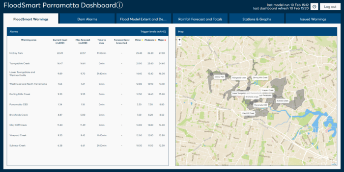
In times of emergency and imminent flood the most important information should be accessible in one-click and deliver clear insights immediately. Flash pro-actively informs users through SMS and e-mail when forecasted water levels breach alarm thresholds. The SMS and e-mail guide the user easily to the dashboard. With one click they can open up the dashboard on any device.
Upon opening the operators directly see the areas of the creeks and main river that are at risk of flooding. Easy to interpret colors indicate which alarm thresholds are reached. For all key locations the user can see the current observed water level and how much time it takes for the water to rise until its maximum water level. This information gives the operators and emergency response team lead-time for action.
As the user navigates from right to left the operator dashboard provides aggregated and detailed information on rainfall aggregated over the tributary creek catchments over multiple periods in the past and future, the flood extent and cadastral information, detailed graphs to follow the flood at key and a list of issued warning.
Misinterpretation of the data is a risk in mitigating the impact of floods. It can result in miscommunication in the emergency response team making their efforts ineffective. To minimize this risk the information shown in the dashboard is the same for every user. The information doesn’t change based on user rights and the information display is set up as simple as possible.
Works on any device
Accessibility of flood forecasting information is key in mitigating the impact of an imminent flood. If the accessibility is poor it restricts the emergency response team to fully leverage the forecast information to their advantage.
One of the major advantages of Flash compared to conventional flood forecasting systems is that it completely runs in the cloud. Users can access information securely via an internet browser instead of through local servers and software on a PC in the office. This greatly increases the accessibility of the flood forecast information as it can be accessed from anywhere, as long as there’s an internet connection.
To further increase accessibility we optimized the operator dashboard to work on any device. Users can open the dashboard on their phone, tablet, laptop and PC, from home, on the road and in the office.
Training with scenario’s
Together with the emergency response teams six training scenarios were developed to train the ER-specialists. Within the operator dashboard these six training scenarios can be opened. These scenarios follow a realistic propagation of a severe flood in the catchment and are part of a training procedure frequently carried out by the emergency response team.
Flash works anywhere on the planet
Flash and its new operator dashboard can be deployed anywhere on the planet to provide communities, individuals and business owners with vital information to know if they are at risk and what lead time they have got to take action.