Tool for calculating flood retention area
- Client
- Hoogheemraadschap Hollands Noorderkwartier
- Year
- 2020
- Location
- Heerhugowaard
Spatial developments are taking place on a large scale in Noord-Holland. ‘Hoogheemraadschap Hollands Noorderkwartier’ (HHNK) wants to prevent the vulnerability to flooding from increasing. In order to maintain sufficient water storage in the future, the policy is to strive for a hydrologically neutral situation. This means that no water storage may be lost during and after project realization. Nelen & Schuurmans, in collaboration with HHNK, has expanded the existing methodology to compensate for above-standard precipitation events during spatial developments. The methodology has been translated into an instrument, the compensating storage tool, with which the permit procedure is easily completed.
The challenge
The basis of developing in a hydrologically neutral manner is compensating for the loss of storage. So, if a waterway is filled in, the same storage capacity has to be created somewhere else. Hence the slogan: ‘filling equals digging’. In addition, HHNK requires compensation for the soil storage that is lost as a result of pavement. The compensation requirement indicates how much new water surface is to be constructed to compensate for the extra discharge to the water system. In other words, ‘paving equals compensating’.
In the study “Bescherming Wateroverlast Noorderkwartier 2”, the water system was also tested for above-standard precipitation events. This often involves the occurrence of water puddles in the street. Development in such places (elevation and paving) will result in an extra burden on the surrounding area. After all, storage at ground level is ‘lost’.
HHNK therefore wants to expand the compensation requirement from the original Hydrological Neutral Development policy. In addition to (1) ‘filling equals digging’ and (2) ‘paving equals compensating’, there is an additional requirement; (3) ‘raising is compensating for the lost storage at the ground level’.
Our solution
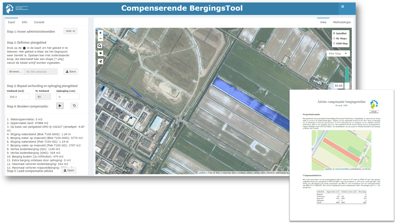
The compensation computation determines the total storage in the project area, which includes the storage in the ground plus the storage at ground level. Based on this storage, it is determined how much water surface must be added to the water system in order to equalize the storage and discharge in the water system.
The interpretation of the new compensation requirement ‘raising is compensating’ has been investigated on the basis of various water nuisance scenarios. The compensation percentage has been derived for the storage at ground level, so still excluding compensation for lost soil storage. The compensation percentage indicates which percentage of a new development area must be compensated in square meters of open water. The percentage is determined per scenario by dividing the volume of water that is stored at ground level by the increase in the water level in the nearby watercourse. This area is then divided by the project area.
Depending on the area, a peak rain event or a block rain event is normative. So, it is determined for both events how much water is stored in the soil and at the ground level and which water level rise occurs in the system. Subsequently, the disposal at the ground level is compared for both events and the maximum is taken as the normative value for the storage at the ground level.
The complete compensation computation has been converted to an instrument, known as ‘the compensating storage tool’. In this tool it is possible to draw the project area on the map and specify the pavement. The tool calculates the compensation requirement in the blink of an eye and presents it in a well-arranged table. The results can be downloaded immediately as a PDF report.
The outcome
The Hydrological Neutral Development methodology has been expanded to compensate for the lost storage at ground level and has been translated into an IT instrument; the compensating storage tool. Advisors from the Dutch Water Board use this tool to determine the compensation requirement in a few steps. As a result, a permit is processed thoroughly and fast.
All cases